With the hot, and most of the time, humid weather conditions that come with summer in the Ohio Valley the threat of a somewhat rare type of severe thunderstorm event also looms. The event is known as a derecho.
A derecho (pronounced similar to "deh-REY-cho") is a widespread, long-lived wind storm that is associated with a band of rapidly moving showers or thunderstorms. Although a derecho can produce destruction similar to the strength of tornadoes, the damage typically is directed in one direction along a relatively straight swath. As a result, the term "straight-line wind damage" sometimes is used to describe derecho damage. By definition, if the wind damage swath extends more than 240 miles (about 400 kilometers) and includes wind gusts of at least 58 mph (93 km/h) or greater along most of its length, then the event may be classified as a derecho.
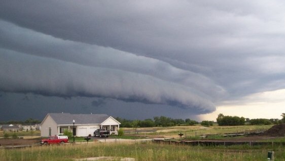
The gust front "arcus" cloud on the leading edge of a derecho-producing storm system. The photo was taken on the evening of July 10, 2008 in Hampshire, Illinois. Credit: Brittney Misialek
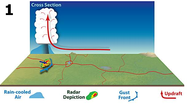
1.) Derecho development is necessarily tied to the formation of bow echoes. A bow echo usually arises from a cluster of thunderstorms, but also may evolve from a single strong storm. Bow echoes most frequently occur when atmospheric winds are relatively strong and unidirectional (i.e., they vary little in direction with height but increase in speed). As the rain-cooled downdraft of a thunderstorm reaches the earth's surface, it spreads horizontally, most rapidly in the direction of the mean atmospheric flow. As the cool, dense air spreads outward, it forces the lighter, warm and moist air surrounding the storm up along the leading edge of the outflow, or gust front (see figure below, with mean flow assumed to be from left to right). Gust fronts often are marked by a band of ominous, low clouds known as "arcus." (pictured above)
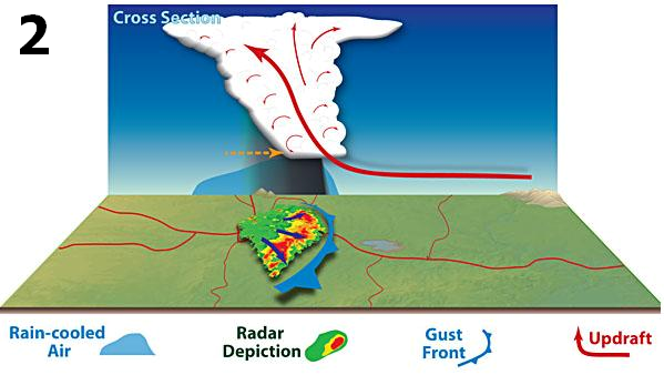
2.) The rain produced by the newer storms reinforces the cold pool, strengthening the inflow of air from the back side of the developing storm complex and encouraging the downward transport of higher momentum winds from aloft. These processes can enable the system to attain a nearly steady-state condition. This increases the longevity and strength of the entire system and is what allows the storm to travel such a large area over a short amount of time. At this point, the convective system typically exhibits a pronounced bow shape on radar (see figure below).
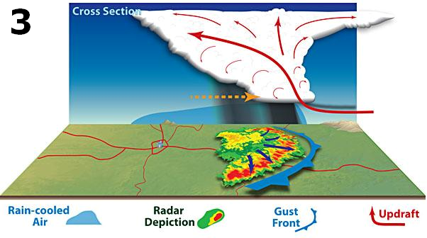
3.) As the thunderstorms continue to increase in coverage, even more rain-cooled air reinforces the cold pool (pictured below). The line of storms continue to accelerate either as one large bow echo or multiple smaller bow echoes within an overall line. At this point, widespread and persistent wind damage has been occurring for a prolonged period of time.
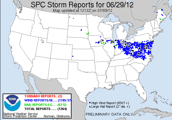
Below is an example of damaging wind reports left behind by the June 29, 2012 derecho that swept from the upper Midwest to the central Atlantic coast in a matter of hours. Almost 1,200 reports of damaging winds were received with numerous reports of wind gusts at hurricane force or greater (74 MPH). Powerful winds likely extended into the Atlantic Ocean.
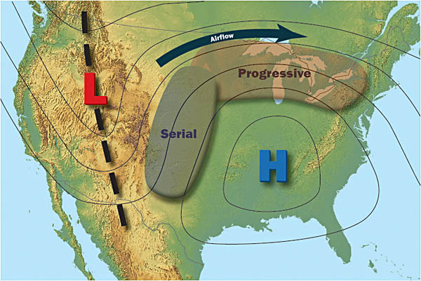
Below is an image depicting favorable weather patterns for derecho formation. A progressive derecho needs a very unstable (hot and moist) environment with relatively strong winds aloft. Therefore, the most favorable area for this type of storm to develop is on the periphery of a strong area of high pressure aloft where the greatest overlap of hot and dry conditions and stronger wind aloft occurs. In the image below the strongest winds aloft are where the pressure lines are closest together.
One interesting note is that progressive derechos are much harder to forecast because of the environment that they thrive in. Many times, the best overlap of stronger winds aloft and hot and muggy conditions are in an area where the atmosphere is "capped" (a thin layer of warmer air in the low to mid levels that can inhibit upward vertical motion needed for thunderstorm updrafts). The cap is caused by the overall sinking motion that a high pressure aloft exhibits. The only way to initiate thunderstorms in this environment is through a triggering mechanism such as a disturbance in the mid to upper level flow, or from surface convergence caused by a frontal boundary in the area. Many times, these features are very subtle and hard to predict. Therefore, a progressive derecho can quickly develop with very little warning. To put this in perspective, consider the wind damage map from above. Millions of people from the upper Midwest to along the Atlantic coast were heavily impacted throughout the day by a storm complex that initiated from a subtle disturbance in the upper level flow over northwest Iowa.
Serial derechos develop along a line more parallel to the mid level flow and therefore are a much longer line of storms, however travel shorter distance. The overall wind profile contains more directional shear (turning winds with height) which creates smaller but more bow echoes and increases the chance of brief tornadic spin-ups. Serial derechos are overall easier to forecast due to the nature of the large scale system that typically creates them.
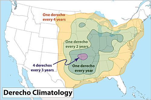
Derechos in the United States most commonly occur along two axes. One extends along the "Corn Belt" from the upper Mississippi Valley southeast into the Ohio Valley, and the other from the southern Plains northeast into the mid Mississippi Valley (figure below). During the cool season (September through April), derechos are relatively infrequent but are most likely to occur from east Texas into the southeastern states. Although derechos are extremely rare west of the Great Plains, isolated derechos have occurred over interior portions of the western United States, especially during spring and early summer. Additional climatological information on United States derechos is available here.
70% of all derechos occur between the months of May-August (the warm season). The other 30% occur during the cool season.
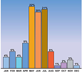
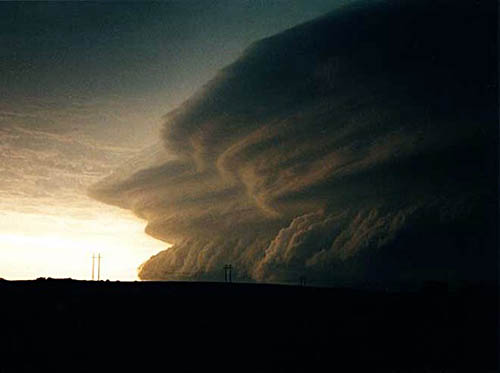
Photo taken by Doug Berry of the very impressive shelf cloud on the leading edge of the "People Chaser" Derecho of May 27, 2001 near Fort Supply, Oklahoma.
For more information and acknowledgements go to the Storm Prediction Center's About Derechos page.


 Weather Story
 Weather Map
 Local Radar
 Follow us on YouTube